
Counting the waves…
Counting the waves…
A refined fusion of water purity, environmental stability, and communal vibrancy for Bon Secour Bay Shoreline.
View MethodologyAnalyzed via live sensors and environmental data.
Wave height, wind, and atmospheric stability.
Live footfall and crowd balance metrics.
Community reviews and curated sentiment.
“You'll trade beach umbrellas for great blue herons on this tidal estuary where Bon Secour Bay meets the mainland. The shoreline here smells of salt marsh and sweet bay magnolia, and the only footprints in the mud belong…”
Limited recent visitor reports — live OBI telemetry is your best guide for current conditions.
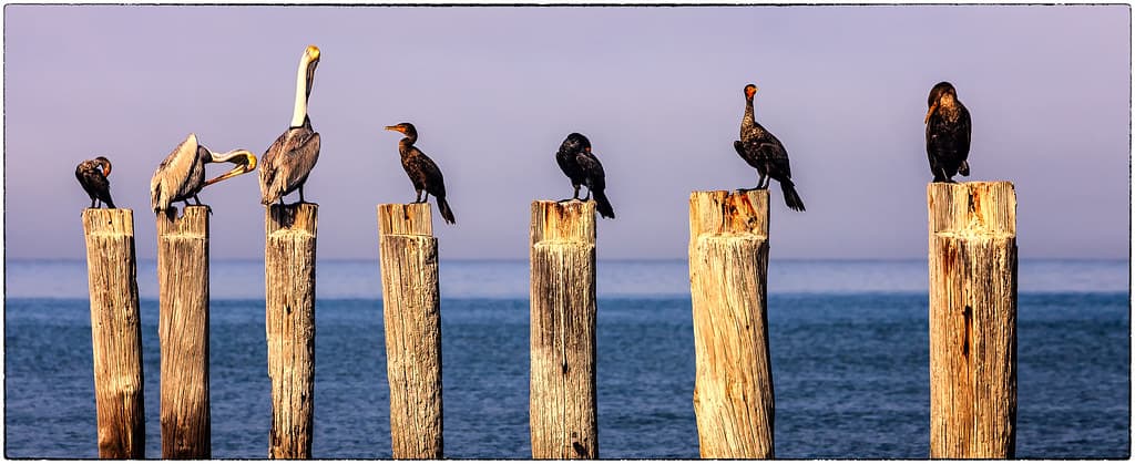
The shoreline along Bon Secour Bay refuses to behave like a typical Gulf Coast beach. Instead of wide sand ribbons, you'll find quiet tidal flats edged with cordgrass and needle rush, punctuated by gnarled live oaks draped in Spanish moss. The water laps gently against muddy banks where fiddler crabs scuttle sideways and oyster shells crunch underfoot. This is Alabama's working waterfront—a place where fishing boats bob at weathered docks and brown pelicans dive for mullet in the shallows.
Wade into the tea-colored water and you'll feel soft sediment between your toes, the bay bottom yielding with each step. The shoreline changes with every tide: high water brings the bay up to the marsh edge, while low tide exposes acres of flats where egrets stalk minnows. Across the water, uninhabited islands rise as dark green smudges on the horizon, their beaches accessible only by boat.
Crystal lagoon with rocky outcrop
White cliffs over a desert beach
Launch at high tide only
Herons hunt exposed tidal zones
Mud and oyster shell walking
Where it is
Bon Secour Bay Shoreline
Bon Secour, Alabama, USA
30.318400°, -87.732600°
Weather
Loading…
Swell
—
Temp
Warm · Restorative
UV Index
Moderate
Wind
—
Tidal State
Last known
Max Sunlight
—
Ideal Shade
—
May - Sep (Peak)
Jan - Dec (Off-season)
Historical data suggests peak visibility and stable sea temperatures occur during the prime visitation window.
Select a category to load nearby places.
Unlock restaurants, luxury stays and curated maritime experiences within 2km
Bon Secour Bay offers calmer, shallower waters compared to Gulf-facing beaches, making it generally suitable for wading and swimming. However, this is a bay environment with potential for jellyfish, particularly in warmer months, and occasional strong currents. There are no lifeguards on duty. The shoreline features muddy areas and oyster beds that can cause cuts, so water shoes are recommended. Always check local conditions before entering the water and supervise children closely in this undeveloped, natural setting.
Bon Secour Bay is accessible year-round, with each season offering different experiences. Spring and fall provide mild temperatures (60s-70s°F) ideal for beachcombing and birdwatching with fewer crowds. Summer brings warm waters perfect for swimming but higher humidity and occasional afternoon thunderstorms. Winter offers solitude and excellent wildlife viewing, though water is too cold for most swimmers. Spring and fall migration seasons are particularly rewarding for nature enthusiasts visiting this scenic, undeveloped shoreline.
Bon Secour Bay Shoreline is accessed via State Highway 180 west from Gulf Shores. Public access points are limited along this undeveloped coastline. The Bon Secour National Wildlife Refuge offers the most reliable public access with designated parking areas. From Gulf Shores, take Highway 180 west approximately 10 miles, following signs to the refuge. Parking is free but limited at access points. Roads are paved but narrow, and some areas require short walks to reach the shoreline.
Bon Secour Bay Shoreline is largely undeveloped with no on-site amenities, restrooms, or food facilities. The small community of Bon Secour, about 2-3 miles away, has limited services including a few local seafood restaurants and convenience stores. For more dining options, accommodations, and full amenities, visitors typically stay in nearby Gulf Shores or Orange Beach, both approximately 15-20 minutes away. Plan accordingly by bringing water, snacks, and using facilities before arrival.
Bon Secour Bay is part of an important wildlife corridor and offers exceptional nature viewing. The area hosts migratory shorebirds, wading birds like herons and egrets, and occasionally dolphins in the bay waters. The adjacent Bon Secour National Wildlife Refuge protects critical habitat for endangered sea turtles and the Alabama beach mouse. Visitors often spot ospreys, pelicans, and during migration seasons, numerous songbird species. Early morning and late afternoon provide the best wildlife viewing opportunities along this pristine, scenic shoreline.
Photos