Counting the waves…
Counting the waves…
A refined fusion of water purity, environmental stability, and communal vibrancy for Chapel Beach.
View MethodologyAnalyzed via live sensors and environmental data.
Wave height, wind, and atmospheric stability.
Live footfall and crowd balance metrics.
Community reviews and curated sentiment.
“You'll hear Chapel Beach before you see it—the metronome wash of Lake Superior against a shoreline hemmed by two-hundred-foot sandstone ramparts. The sand here is bone-white, fine as confectioner's sugar, earned after a…”
Limited recent visitor reports — live OBI telemetry is your best guide for current conditions.
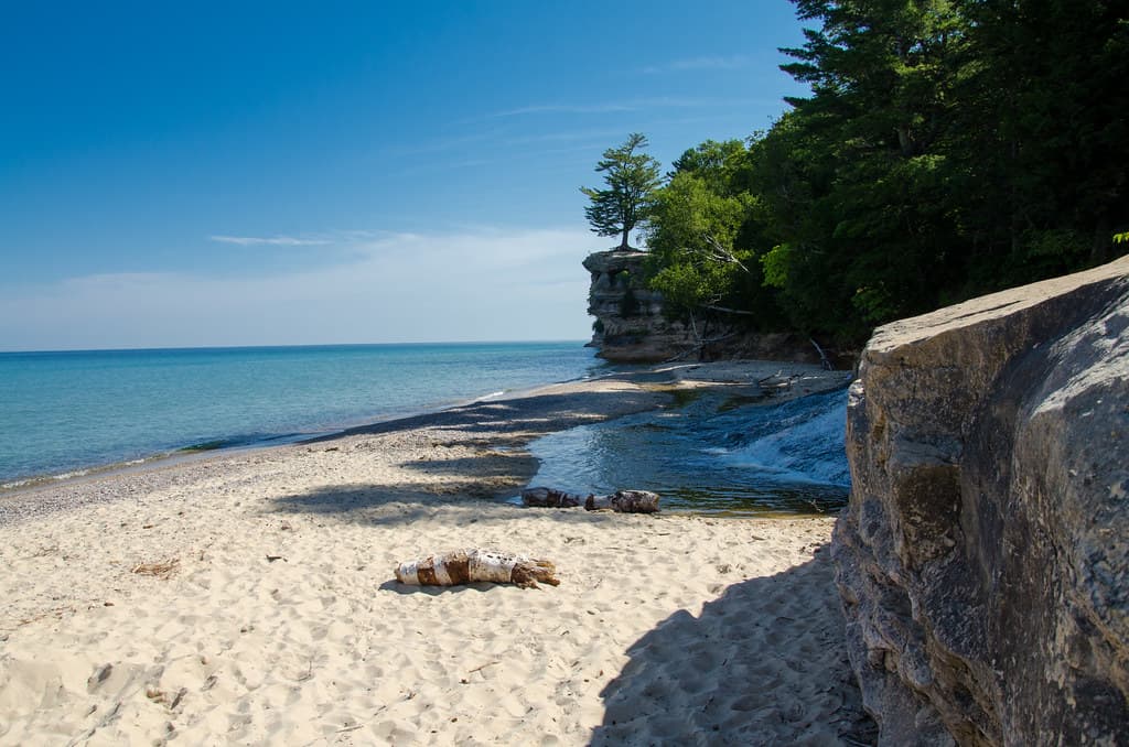
Chapel Beach unfolds in a shallow arc at the base of striated sandstone cliffs that glow rust and amber when late-afternoon sun rakes across their mineral-stained faces. The beach itself stretches roughly half a mile, its pale sand meeting water so cold it numbs your shins in seconds, even in August. Driftwood logs, bleached silver by seasons of ice and sun, scatter across the upper beach like sculptures.
You earn this place. The four-mile Chapel Loop Trail threads through sugar maple and hemlock before descending to the shore, where the cliffs rise in layered bands of red, white, and orange—iron oxide painting centuries in stone. Alternatively, kayakers paddle east from Sand Point, navigating open water that can turn from glassy to whitecapped within an hour. Either approach demands respect for Superior's temperament.
Long-tail boats moored in clear water
Crystal lagoon with rocky outcrop
Four miles through hardwood forest
Iron-streaked sandstone layers at beach level
Open-water route along Pictured Rocks
Where it is
Chapel Beach
Munising, Michigan, USA
46.582500°, -86.358700°
Weather
Loading…
Swell
—
Temp
Warm · Restorative
UV Index
Moderate
Wind
—
Tidal State
Last known
Max Sunlight
—
Ideal Shade
—
May - Sep (Peak)
Jan - Dec (Off-season)
Historical data suggests peak visibility and stable sea temperatures occur during the prime visitation window.
Select a category to load nearby places.
Unlock restaurants, luxury stays and curated maritime experiences within 2km
Swimming at Chapel Beach requires caution due to Lake Superior's consistently cold water temperatures, typically 40-55°F even in summer. The lake's unpredictable currents and lack of lifeguards mean swimmers should stay close to shore. The beach's remote location means help isn't immediately available in emergencies. Most visitors wade in the shallows or simply enjoy the scenery. The water is clean and clear, but hypothermia risk is real even for strong swimmers. Always check weather conditions before visiting, as Lake Superior can change rapidly.
Summer months from June through September offer the most accessible conditions, with comfortable temperatures and calmer lake waters. July and August provide the warmest weather for hiking the trail to reach the beach. However, Chapel Beach is stunning year-round for those prepared for adventure. Fall brings spectacular foliage colors, while winter creates dramatic ice formations along the cliffs, though access becomes extremely challenging. Spring can be muddy and buggy. Keep in mind that Lake Superior weather is unpredictable in any season, so prepare for changing conditions.
Chapel Beach is accessible only by hiking or kayaking—there's no road access. The most common route is the Chapel Basin/Chapel Beach Trail from the Chapel parking area off Chapel Road near Munising. The hike is approximately 2.8 miles one-way through forest terrain with some elevation changes. Park at the designated Chapel trailhead lot; arrive early during summer as parking fills quickly. A Pictured Rocks National Lakeshore vehicle pass is required. Alternatively, experienced kayakers can paddle from Munising, though this requires proper equipment and skills for Lake Superior conditions.
Chapel Beach itself has no amenities—it's completely undeveloped wilderness. There are no restrooms, food services, or shelters at the beach or along the trail. Visitors must carry all supplies, including water, food, and toilet paper for Leave No Trace principles. The nearest services are in Munising, about 15 minutes by car from the trailhead, offering hotels, restaurants, and grocery stores. Backcountry camping is permitted at designated sites near Chapel Beach with a free permit from Pictured Rocks National Lakeshore, allowing multi-day exploration of the area.
Chapel Beach provides stunning views of the famous sandstone cliffs of Pictured Rocks, but Chapel Rock itself isn't visible from the beach. To see Chapel Rock—the iconic rock formation with a tree on top—you need to hike the additional Chapel Rock Trail spur (about 0.5 miles from the beach junction). Chapel Falls, a scenic waterfall, is accessed via a different trail branch before reaching the beach. Many visitors combine all three destinations in one day hike, totaling about 10 miles round-trip, making for a full day of exploration in this beautiful section of Pictured Rocks.
Photos