
Counting the waves…
Counting the waves…
A refined fusion of water purity, environmental stability, and communal vibrancy for Playa Costa de los Naufragios.
View MethodologyAnalyzed via live sensors and environmental data.
Wave height, wind, and atmospheric stability.
Live footfall and crowd balance metrics.
Community reviews and curated sentiment.
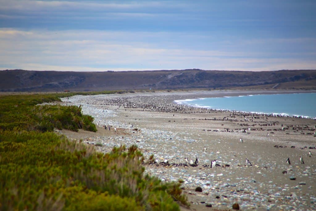
“You stand at the threshold between two oceans, wind howling across a beach strewn with whale vertebrae and rusted anchors. To the east, the Atlantic churns; westward, the Magellan passage opens toward Tierra del Fuego,…”
Limited recent visitor reports — live OBI telemetry is your best guide for current conditions.
The gravel crunches differently here—rounded stones the size of fists, clacking against each other with each retreating wave like an infinite abacus counting the drowned. You walk the tide line scanning for ship's fittings, twisted iron cleats, glass fishing floats worn milky by decades of tumbling. A length of hawser rope, thick as your forearm and stiff with salt, emerges from the kelp wrack. Above the beach, tussock grass bends horizontal in fifty-knot gusts that never truly stop, just pause to gather strength.
The lighthouse at Cabo Vírgenes stands three kilometers south, its red and white bands visible when squalls permit. Between here and there, nothing interrupts the sweep of Patagonian steppe meeting Southern Ocean. Magellanic penguins commute past you toward inland burrows, unbothered by the wind that forces you to brace against every gust. A South American sea lion skull rests half-buried in shingle, eye sockets filled with smaller stones, polished smooth as river rock.
Credit: PixabayShipwreck beachcombing
Credit: PixabayStrait horizon photography
Historical nautical artifacts scattered
Where two oceans converge
Continental South America's largest
Prime Visitation
Anytime | Less Crowds
Where it is
Playa Costa de los Naufragios
Cabo Vírgenes, Santa Cruz, Argentina
-52.374600°, -68.413500°
Weather
Loading…
Swell
—
Temp
Warm · Restorative
UV Index
Moderate
Wind
—
Tidal State
Last known
Max Sunlight
—
Ideal Shade
—
Jan - Dec (Peak)
Mar - Nov (Off-season)
Anytime | Less Crowds
Select a category to load nearby places.
Unlock restaurants, luxury stays and curated maritime experiences within 2km
Swimming is not recommended at this beach due to extremely cold water temperatures year-round, strong currents from the Strait of Magellan, and unpredictable winds. The Atlantic waters here rarely exceed 10°C (50°F). The pebble shore and exposed location create challenging conditions. This beach is best appreciated for walking, photography, and observing the dramatic coastal landscape. Always stay clear of the water's edge during high tide and windy conditions, as waves can be surprisingly powerful and unpredictable.
The beach can be visited year-round, though conditions vary significantly. Summer months (December-February) offer the longest daylight hours and slightly milder temperatures, typically 10-15°C (50-59°F). Spring (October-November) and autumn (March-April) bring fewer visitors and dramatic lighting for photography. Winter visits are possible but expect harsh winds and temperatures near freezing. Regardless of season, always prepare for strong Patagonian winds and rapid weather changes. The remoteness means crowds are minimal throughout the year.
Access requires traveling to Cabo Vírgenes, approximately 130 km south of Río Gallegos via Route 1. The journey takes about 2 hours on mostly unpaved roads requiring a sturdy vehicle, preferably 4WD. From the Cabo Vírgenes lighthouse and penguin reserve, the beach is accessible by foot along coastal paths. No public transportation serves this area; rental cars or organized tours from Río Gallegos are the only options. Verify road conditions before departure, especially after rain or snow.
No facilities exist at the beach itself. The nearest services are in Río Gallegos, 130 km north, offering hotels, hostels, restaurants, and supermarkets for provisions. The lighthouse area has basic visitor facilities but no accommodations. Bring all food, water, and supplies for your visit, as there are no shops or restaurants at Cabo Vírgenes. Some travelers stay in Río Gallegos and make a day trip. Always carry extra food and emergency supplies due to the remote location and unpredictable weather.
This beach offers an authentic end-of-the-continent experience at the entrance to the Strait of Magellan, where Atlantic and Pacific influences meet. The name translates to "Shipwreck Coast," reflecting its dramatic maritime history. The remote location provides exceptional solitude and wilderness atmosphere rarely found elsewhere. Dramatic Patagonian landscapes, powerful winds, and the sense of standing at one of South America's southernmost points create unforgettable experiences. Wildlife including penguins, sea lions, and marine birds frequent the area seasonally, adding to its wild character.
Photos