
Counting the waves…
Counting the waves…
A refined fusion of water purity, environmental stability, and communal vibrancy for Nullarbor Plain Beach.
View MethodologyAnalyzed via live sensors and environmental data.
Wave height, wind, and atmospheric stability.
Live footfall and crowd balance metrics.
Community reviews and curated sentiment.
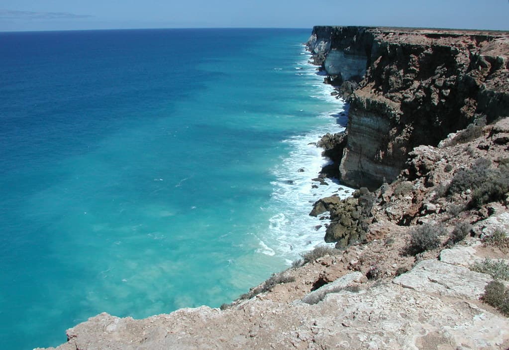
“You'll stand on limestone cliffs that plunge 60 meters into the Southern Ocean, salt wind pressing against your face, watching waves explode into white plumes far below. The Nullarbor Plain delivers what its Latin name…”
Limited recent visitor reports — live OBI telemetry is your best guide for current conditions.
The Eyre Highway skirts the continent's southern edge here, and when you pull off onto the rough track leading to the cliffs, you enter a landscape stripped to its essentials. Rust-red earth gives way abruptly to pale limestone, fractured and sheared by millennia of Southern Ocean storms. The cliffs run in both directions as far as you can see—a geological drama playing out across 200 kilometers of coastline. Below, waves surge into blowholes and sea caves, their roar carried up on wind that never stops.
This isn't a beach for swimming or sunbathing. You're here to witness scale: the vast indifference of ocean meeting continent, the way afternoon light turns the water from steel-blue to pewter, the absolute silence once you kill your engine. Whales breach offshore during their annual migration. Wedge-tailed eagles ride thermals along the cliff edge. The sparse vegetation—saltbush, bluebush, samphire—clings low to the ground.
Capture blowholes during high swell
Follow limestone shelf both directions
Southern Rights migrate June through October
Where it is
Nullarbor Plain Beach
Norfolk, Western Australia, Australia
-31.462900°, 130.887900°
Weather
Loading…
Swell
—
Temp
Warm · Restorative
UV Index
Moderate
Wind
—
Tidal State
Last known
Max Sunlight
—
Ideal Shade
—
Jan - Dec (Peak)
Mar - Nov (Off-season)
Historical data suggests peak visibility and stable sea temperatures occur during the prime visitation window.
Select a category to load nearby places.
Unlock restaurants, luxury stays and curated maritime experiences within 2km
Swimming conditions at remote Nullarbor beaches can be challenging and unpredictable. The Southern Ocean coastline features strong currents, cold water temperatures, and often lacks patrolled areas or lifeguard services. There are no shark nets or safety infrastructure. If you choose to swim, stay close to shore, never swim alone, and be extremely cautious of rips and undertows. Many visitors prefer to enjoy the beach for scenic walks, photography, and wildlife watching rather than swimming due to these safety considerations.
The Nullarbor region is accessible year-round, though each season offers different experiences. Winter (June-August) brings cooler temperatures and occasional rain, while summer (December-February) can be extremely hot. Spring (September-November) and autumn (March-May) offer milder weather ideal for coastal exploration and whale watching. The Great Australian Bight migration season (June-October) is particularly special for spotting southern right whales. Pack layers regardless of season, as coastal conditions can change rapidly with strong winds common throughout the year.
Accessing beaches along the Nullarbor Plain typically requires driving the Eyre Highway, with various lookout points and beach access roads branching south toward the coast. Many access points are unsealed roads requiring high-clearance or 4WD vehicles. Parking is generally informal—cleared areas near cliff tops or beach access points rather than designated lots. Distances between fuel stops can exceed 200km, so plan accordingly. Always check road conditions before travelling, carry emergency supplies, and inform someone of your plans when visiting these remote locations.
The Nullarbor region is extremely remote with very limited facilities. Basic accommodation and fuel are available at roadhouses along the Eyre Highway (Nullarbor Roadhouse, Border Village, Eucla), spaced 100-200km apart. These typically offer simple rooms, camping areas, and basic food options—don't expect fine dining. There are no facilities directly at beach access points: no toilets, showers, or fresh water. Visitors should be completely self-sufficient, carrying food, water, camping equipment, and emergency supplies. The nearest towns with full services are hours away.
The Nullarbor coastline, particularly around the Head of Bight, is one of Australia's premier whale-watching destinations. Southern right whales migrate to the Great Australian Bight's sheltered waters (June-October) to calve and nurse. From clifftop vantage points, you can often spot mothers with calves remarkably close to shore. While the Head of Bight has a dedicated viewing platform with entry fees, other Nullarbor coastal access points may offer whale sightings during migration season. Bring binoculars for the best experience, and visit during peak season for optimal viewing opportunities.