Counting the waves…
Counting the waves…
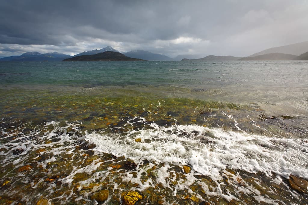
Isla Redonda Oeste occupies strategic geography: close enough to Chilean waters that maritime boundaries become conversation, far enough from Ushuaia that silence replaces the cruise-port din. The beach itself runs perhaps three hundred meters of mixed pebble and coarse sand, bookended by rock outcrops where giant kelp anchors in the shallows. At low tide, the kelp lies exposed like bronze cables across the stones; at high water, it floats vertically, forming submerged forests that filter the light to emerald. The facing vista dominates: Navarino Island's peaks rise abruptly from sea level, their flanks striped with snow gullies even in summer. Clouds catch on the ridgelines, sometimes concealing the summits entirely, other times parting to reveal granite spires that seem impossibly vertical. The channel's water moves with purpose here, pushed by tides and funneled by geography, creating standing waves and whirlpools that mark the current's intensity. Occasionally, a Chilean naval patrol vessel passes, or a sailboat bound for Cape Horn. Landings require permission from boat captains who read weather and tide tables like scripture. The wind can funnel through the channel with frightening speed, transforming calm water to whitecapped chaos within an eyeblink. But when conditions align and you step onto this western beach, you stand at the functional edge of two nations, surrounded by water that has carried Yámana bark canoes, British survey ships, and modern yachts attempting the uttermost south.
Places, rentals, tours and events within walking and driving distance of Playa Isla Redonda Oeste.
Photos
Visiting Playa Isla Redonda Oeste requires careful planning due to its remote island location near the Argentina-Chile border. Water temperatures are dangerously cold (4-9°C), making swimming unsafe. Weather can change rapidly, and the channel location experiences strong currents and winds. Safety depends heavily on your boat operator's experience and equipment. Always travel with reputable guides, wear layered clothing, and carry emergency supplies. Cell phone coverage is unreliable. The remoteness means evacuation would be challenging, so avoid risks and follow your guide's instructions carefully.
December through February offers the best conditions for visiting this western island beach, with relatively stable weather, temperatures of 10-15°C, and extended daylight (up to 17 hours). These summer months provide the calmest channel waters and most reliable boat access. March and November are shoulder months with fewer visitors but increased weather variability. Winter months (June-August) face extreme conditions, limited tour availability, and very short days. Even in peak summer, be prepared for sudden weather changes typical of this transitional channel zone between Argentina and Chile.
Access requires boat transportation from Ushuaia, as Isla Redonda has no land connections. You must arrange tours through Ushuaia-based operators offering Beagle Channel expeditions, typically as part of broader island-hopping itineraries. The journey duration varies depending on weather and vessel, but expect at least 45-90 minutes from Ushuaia's port. Charter boats may offer more flexible visits. Weather conditions frequently impact schedules, so book with operators who offer flexible cancellation policies. Confirm your operator has proper permits for this border channel area.
Playa Isla Redonda Oeste has no facilities, services, or accommodations whatsoever. This is an uninhabited island beach in a remote wilderness area. All lodging, dining, and services are based in Ushuaia, which serves as the departure point for visits. Bring all necessary supplies including food, water, warm clothing, and safety equipment. Tours typically operate as day trips returning to Ushuaia. There are no restrooms, shelters, or emergency services on the island. Self-sufficiency is essential, and environmental responsibility requires packing out all waste.
Playa Isla Redonda Oeste occupies a unique position in the Beagle Channel where Argentine and Chilean territories converge, offering distinctive perspectives of this international waterway. The western orientation provides different coastal exposure and ecological characteristics compared to eastern island sectors. This location sits in a transitional zone where channel conditions shift, creating unique maritime environments. The beach offers exceptional opportunities for observing channel geography, subantarctic coastal ecosystems, and the dramatic interplay of mountain, water, and sky characteristic of this remote southern region. True wilderness experience defines this destination.